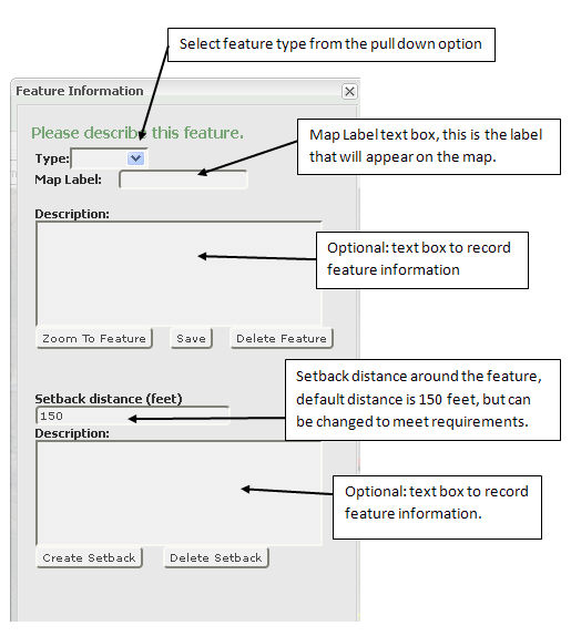
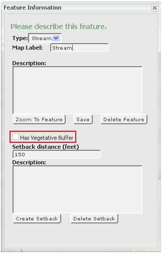
Feature Information window allows you to choose a feature type, add a map label and provide a description of the feature. After saving the feature, you have the option to apply a setback to the feature. By default the setback is 150 feet (you may change that number to meet your requirements). When choosing a stream, you also have the option to apply a 35 foot vegetative buffer. With a road you will be required to name the road in the map label box.
In the "Feature Information" box you will select the
feature type in the “Type” box click on the ![]() to see
the options for the feature you have created.
to see
the options for the feature you have created.
Type Selection:
When selecting a Stream as a line feature, you will have the option
to apply a vegetative buffer ![]() .
By selecting this, a 35 foot buffer will be placed around the selected
stream.
.
By selecting this, a 35 foot buffer will be placed around the selected
stream.
When selecting Road in the line feature, you are required to name the road in the map label box. The road name will not appear until the actual map is printed.
Once you choose a "Type," add a Map Label and provide a description (optional) you must click the Save tab. When feature is successfully saved, you will be notified at the bottom of the information box that your "Feature is successfully saved" (see sample above). You can now add the setback. Default setback distance is 150 feet, but this can be changed to meet your requirements by simply typing in the distance you want, then click on the "Create Setback" tab. This command will automatically apply the setback. Close the information box before creating another feature.
The "Zoom To Feature" tab will zoom in and center your feature in the middle of the map.
The "Delete Feature" tab, when selected, will remove the selected feature from the map and all related information.