Base Layers and Overlays
Base Layers - provide the background for your map. By default,
the Air Photos are turned on allowing you to view your farm on aerial
photography. You may also select a topo map background by simply
clicking in the circle in front of the layer option. Only one layer can
be turned on at a time.
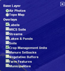
Overlays - are layers when selected that will be visible over top the
base layer, these layers can be toggled on and off at anytime.
- Labels - text assigned to the map when fields and features are
created
- NRCS Soils - Soil boundaries and map unit symbols provided (by
Natural Resource Conservation Service) for the entire aerial image.
- Streams - representation of statewide streams and their names.
Streams will be represented on the image with blue lines. This
layer is not used for mapping purposes, although it can be used as
a guide for digitizing in areas where the stream is not visible.
- Lakes and Ponds - representation of most water bodies larger than
one acre. This layer is not used for mapping purposes, but can
be used as a guide for digitizing water bodies.
- Soils - provides soil
boundaries and information within the perimeter of crop
management units.
- Crop Management Units - fields digitized by you within the farm
listing
- Manure Setbacks - areas within the crop management units that do
not meet the criteria for applying nutrients
- Vegetative Buffers - 35 foot distance from the center of the stream
containing vegetation.
- Farm Features - features digitized within the farm listing, represented
by points, lines,
and polygons.
- Municipalities - Municipal Boundary lines